There are many types of maps for various purposes available. The right choice is of great importance for the prepared trip. You should often take a few maps, among which there should be one with a small pitch (scale), depicting the entire area of the journey, and a few more accurate, individual areas. It is best to take topographic maps about the scale for hiking 1:50000. Instead of a cartographic grid with marked meridians and parallelists, a rectangular topographic mesh is used in such maps, whose lines are usually placed every two centimeters and intersect at a right angle; The distance between them corresponds to one kilometer in the field (kilometer mesh). Each point of the topographic grid can be determined by conventionally accepted coordinates (letter or numerical).
Reading the map
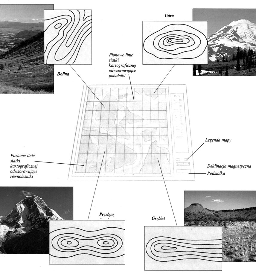
The terrain is generally the result of the erosive activity of the waters, which, sailing the valleys and gorges, gorgeled by hills and mountain ridges. Landscape elements related to human activity, such as expensive, They are unstable, they often change. Therefore, to determine the location of a given area based on the map, You should start by recognizing the rivers, Then the valleys and the highs separating them.
Valley – Lines connecting points of the same amount, So the levels show the valley as a growing language formed by their elongated bulges. Thanks to them you can read from the map what the valley looks like, and especially these parts of it, which are invisible at the outlet. The numbers along the level mean height above sea level.
Pass – The pass is a reduction in the mountain ridge separating the neighboring peaks. It may have a wide saddle or narrow Szczerbina. Standing at the foot of the mountain, we often don't see the pass, Because one peak covers the other. On the map, the pass can be recognized by two wheels made of levels (peaks) connected, closed line.
Ridge – The rivers and valleys are usually separated by mountain ridges. On the map marking them, the levels are arranged in a longitudinal drawing. The spirit level enclosed in an oval means the culmination of the ridge. It is often easier to go along the back than the valley, especially in the area covered with a dense jungle.
Mountain – We can read from the map, how the whole mountain is shaped, Also its slopes invisible to us in place, in which we are. Their tilt and sculpture are evidenced by the course of the levels and their distance relative to each other. The lines of the levels run like this, as if they were painted on the slopes of the mountains.
 Reading the map


