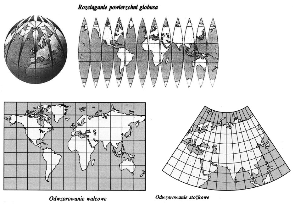
The map is to present as accurately as possible on the plane a selected segment of the convex surface of the earth. Any projection of the globe on the flat surface of the cylinder or cone must deform the image of the earth in one way or another. Therefore, the maps never faithfully reflect all the features of a given area. This applies especially to greater latitudes. One of the best -known cartographic mappings is the mercator's projection commonly used to remove sea maps.
Stretching the surface of the globe – If the globe surface was cut along the meridians and stretch flat flat, There are wide breaks between the pieces near the poles. This is the necessity ,,filling "these breaks on flat maps causes the image of the Earth to distort.
Cylindrical mapping – One of the types of cylindrical mapping is the mesh. In this mapping, the surface of the globe is affected by a roller adjacent to the ball along the equator. After its development, we get a flat map. It is a faithful mapping, which retains the right angles between the meridians and the paralletes. However, the merkator's throw does not faithfully reflect the surface. As you move away from the equator, the distances between the paralletes increase, which deforms the size of the surface, especially areas located in large latitudes (around).
Conical mapping – There are many ways of throwing the globe to surfaces with different properties, disadvantages and advantages. The above map was created by throwing the globe on the cone for the bullet. Constrial mapping is often used when deleting maps of various parts of the world placed in atlases. Also in the case of throwing on the cone, deformations arise, increasing with approaching the cone base; They are not so great, as with many other reproductions.
 The map is to present as accurately as possible on the plane a selected segment of the convex surface of the earth. Any projection of the globe on the flat surface of the cylinder or cone must deform the image of the earth in one way or another. Therefore, the maps never faithfully reflect all the features of a given area. This applies especially to greater latitudes. One of the best -known cartographic mappings is the mercator's projection commonly used to remove sea maps.


