The orientation in the field requires, above all, the ability to use the map and compass. They are used to set out the shortest, and at the same time the safest road in a diverse area. On land it is impossible to determine the roads so precisely, as at sea. There you can set a simple course, because only the wind, tides and shoreline changes introduce corrections. The speed of moving on land depends on many factors – terrain, substrate. ^ climate, current weather. The orientation in the field is associated with the need for permanent changes to the chosen road, bypassing obstacles, and remembering this, to always go back to the trail.
Animal migrations – Many traveling birds have a coded sense of orientation, which allows them to return to the same breeding sites every year, Even from the other end of the earthly globe.
Map orientation
Before setting off, the map should be oriented, that is, using the compass, set it up like this, that the directions specified on it are coincided with the appropriate directions in the field. Then you will be able to designate azimuth, which will indicate the direction of your travel target. In addition, you need to measure the distance to the end point using the compass scale or the map scale. After peeling the azimuth and going on the road, check the often passed objects with marked on the map.
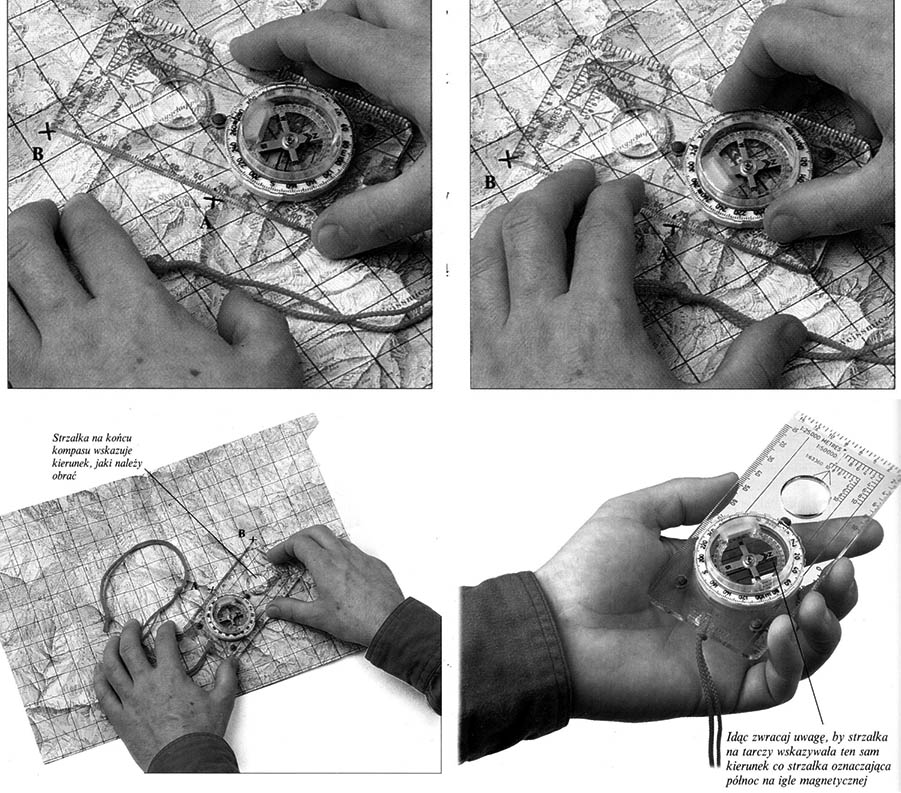 1 To designate azimuth, determining the direction, in which you should go, to reach point B from point A, The compass should be placed on the map between A and B, arrow directed towards B. You need to read the distance between the two points from the scale on the edge of the compass and compare it with the map scale.
2 Without moving the compass, you need to turn the shield inside, that in the parallel to the north-south axle, they coincide with the topographic mesh lines on the map. Red arrow on the shield, North indicating, should show the north direction on the map. In this way, we set the azimuth on the compass, that is, the angle between the direction from A to B and the magnetic north.
3 We rotate the map with the compass until, When the arrow on the shield is in one line with a magnetic needle and will show the north. The arrow at the end of the compass shows the direction, in which point B is in the field.
4 You can now, Holding the compass in the hand, go in the direction indicated by the arrow. Just be careful, that the arrow on the shield indicates the same direction as the magnetic needle. You will then continue to follow the chosen azimuth.


