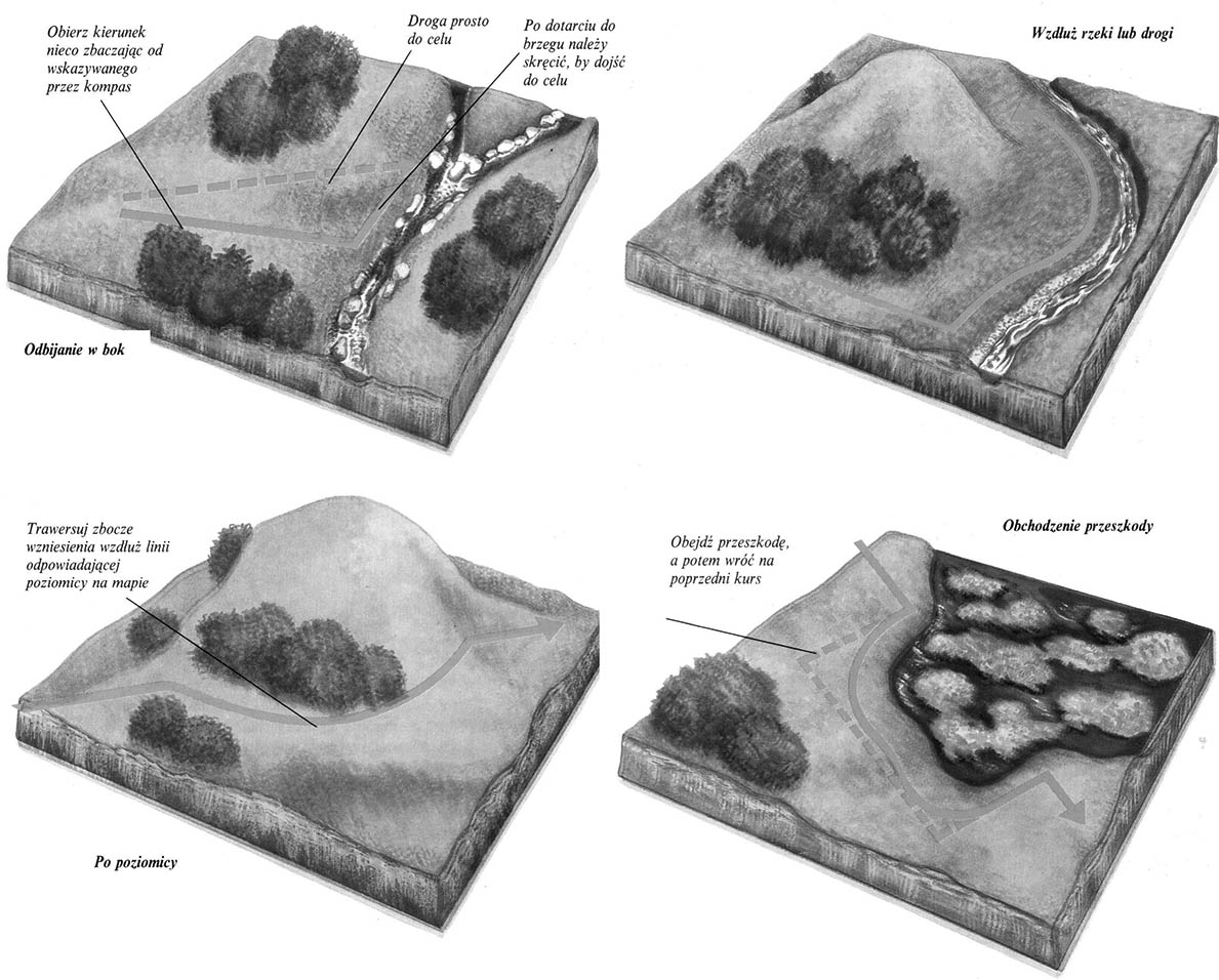
On land, you can not always make sure you can or should be moved constantly in a straight line according to the azimuth indicated by the compass. Poniżej przedstawiono kilka przykładów pokazujących jak omijać przeszkody w terenie, and at the same time not to lose orientation, using the compass. They allow you to avoid unnecessary overlapping of the road or error. Zawsze trzeba pilnować azymutu, Even if the direction he designated at the moment only auxiliary significance.
Bouncing to the side
The compass sets out a direction with azimuth with an accuracy of around 10-20 degrees. After traveling one kilometer, you can, for example, pass the river fork, as on the set above O 300 meters in one side or the other. Worse when being on the shore, You won't know, which way to go, to reach the fork. If you want to avoid this. It will allow, After reaching the river bank, see, in which way to turn, to reach the fork.
Along the river or road
If any obstacle, You can go along the bank of the river, hills or expensive, which will lead us to our destination. First azimuth must be appointed to the field, along which we intend to move. In this example it is the river bank. The hill is about 250 ° from the nearest point on the shore. Then go along the river by celebrating the hill, until it appears at an angle of 250 °. Then turn left, Peeling this azimuth.
After the level
Moving at the same height, We follow the line corresponding to the level on the map. This is an extremely effective method of determining the direction in the field, Especially in the jungle, where it is easier to lose your orientation by going to azimuth than ,,after the level ". This way of walking also saves strength, because the height is not unnecessarily lost.
Celebration of an obstacle
The limits of some major obstacles, such as Trzęsawiska, They are not always exactly deleted on the map. When celebrating them, keep the azimuth peeled, and while bouncing to the side while bypassing the obstacle to measure the distance. After taking the right direction back, it will be known how long to go, to return to the previous course.
Calculation of the road
Moving on foot, you can or count the steps, or use the watch. The length of the steps is different, depending on the terrain and the pace of the march. By measuring time, it is easier to estimate the road traveled. Stop after the first 10 minutes, to calculate the road from the map, what you have. In this way you will learn your pace of march. You can stop later every hour, to correct the course by map and check the luggage. In time, you will learn to determine your average walking speed with great accuracy. A good infantry passes with a load and in difficult terrain on average 4 km per hour, Walking quite quickly.
 On land, you can not always make sure you can or should be moved constantly in a straight line according to the azimuth indicated by the compass. Poniżej przedstawiono kilka przykładów pokazujących jak omijać przeszkody w terenie, and at the same time not to lose orientation, using the compass. They allow you to avoid unnecessary overlapping of the road or error. Zawsze trzeba pilnować azymutu, Even if the direction he designated at the moment only auxiliary significance.


